Journeys through Self Discovery and Natural Events, combining words and photos as I follow local events and my own inner musings
Friday, September 28, 2012
Serenity in the midst of Chaos
I had an adventure yesterday, after I gave some sweet kids up to the Pacific Crest trail to resume their hike that waS interrupted by the fire. Started following little roads I did not know, and found this lovely little stream down in a ravine (yes, some lovely scrambling) just before getting stuck with a rugged flat tire! Took two jacks (yes I carry 2 in my truck!) to get the tire up off the ground... then another hour of hard work trying to break loose a rusty seized up spare tire holder underneath my truck! I managed to do it... with a heartfelt prayer! After I made it finally back to set up to sell at Fire camp, my spare went flat, and to top that off my truck would not start a couple times. Folks there helped me out, and the aired up spare held through the night until I could get the tire repaired with a total now of 3 patches from screws and nails and sharp rocks. Meanwhile I discovered apparently my Starter is the problem, and at least my old truck is a stick shift so I can roll start it until I can get it fixed.
Thank heavens for the photos to remind me of the serenity I found in that rugged ravine before climbing back up into the world of challenges to overcome.
Sunday, September 23, 2012
Beauty and Destruction through Wildfire
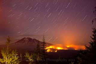
The Cascade Creek Wildfire on Mount Adams has been growing more heavily the last couple days, with estimated burned acreage up to 13,727 acres as of the morning of Sept.23, 2012. You can find details on the inciweb site along with many other major wildfires in the Northwest.
The first map, courtesy of Inciweb, shows the current boundaries. The second map courtesy of Darryl Lloyd of Hood River, is yesterdays boundary map with notations pointing out various features and trails.
These following photos are mine, and I have been selling them in card form at the fire camps, and they are all some of the images in my 2013 Fire Calendar that I am selling at the camp also for $25.
Subscribe to:
Comments (Atom)


